

In the wake of yet another week of severe weather across the South, AccuWeather forecasters say rain and additional thunderstorms may hamper any cleanup efforts this weekend.
Most of the region can expect a dry end to the week before any rain and storms arrive, giving residents a window to clean up after the recent storms or to hold some early outdoor Easter festivities before the stormy weather returns.
A much different story is set to unfold during the first half of the weekend.
“A slow-moving cold front across the South this weekend will become the focus for rounds of heavy showers and thunderstorms,” said AccuWeather senior meteorologist Mike LeSeney.
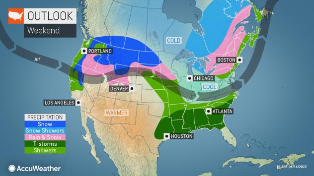 |
The first thunderstorms will develop around southern Missouri and Tennessee on Friday night before becoming more widespread across the region through Saturday. As the storms get farther to the south, higher amounts of moisture and stronger winds in the atmosphere will allow the storms to strengthen.
The most likely location for locally severe thunderstorms Friday night will be in eastern Oklahoma and western Arkansas. Large hail will be the biggest threat, but damaging winds will also be possible. Even an isolated tornado cannot be ruled out.
Severe weather should not be nearly as widespread as earlier this week, but rain and thunderstorms may slow any needed cleanup.
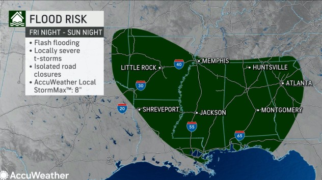
The aforementioned front will become nearly stationary over the weekend. This setup will allow showers and thunderstorms to repeatedly move over the same locations, a pattern known as training. Although the severe threat will likely be lower this weekend than Friday night, the risk of flooding will begin to increase.
“Showers and thunderstorms across Arkansas, Mississippi, Alabama and Georgia will bring the potential for flooding downpours,” LeSeney said.
These showers and thunderstorms could disrupt outdoor plans on Easter Sunday, including Easter egg hunts.
 |
Portions of the region, particularly along the coast of Louisiana, are in severe and extreme drought according to the United States Drought Monitor. Unfortunately, the focus of beneficial rain will be farther to the north.
Regardless, any location that receives heavy rain in a short period of time will have a flooding risk.
“A general 1-3 inches are expected, but 3-6 inches with an AccuWeather Local StormMax of 8 inches are most likely in northern Louisiana, western Mississippi and southern Arkansas over the course of several days,” said AccuWeather senior meteorologist Alex Sosnowski.
Rain will then turn northward and drench the Carolinas and Virginia by Monday. This system may strengthen and continue to move north Monday night and Tuesday, potentially bringing a late-season Nor’easter with wind, rain and mountain snow to the Northeast.