
Potentially dangerous and damaging winds will continue to howl across much of the Central states through Thursday.
Not only will the powerful gusts threaten to knock over vehicles, trigger power outages and cause significant property damage, but the effect of the winds will also exacerbate ongoing drought and elevate the risk of wildfires, AccuWeather forecasters say.
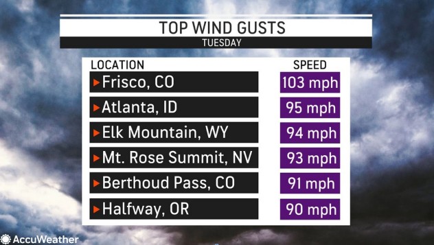
The strong winds began on Tuesday, with wind gusts over 100 mph in some locations. Winds are not expected to be quite as powerful on Wednesday and Thursday, but they will still be powerful enough to cause problems.
 |
“The combination of strong winds, low humidity and warmth can contribute to an extreme fire risk on Wednesday,” said AccuWeather senior meteorologist Mike LeSeney.
Wind gusts between 40 and 50 mph will be common across a massive area stretching more than 1,000 miles from the Canadian prairies to the plains of Texas and Oklahoma. However, some locations will have much stronger winds than that.
“The strongest winds are expected over portions of eastern Wyoming, South Dakota, Nebraska, northern Colorado and northwestern Kansas with gusts of 50-60 mph,” said LeSeney.
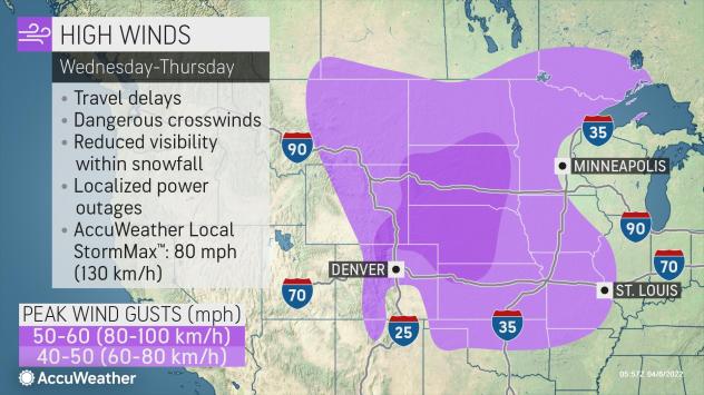 |
At this force, there will continue to be the potential for strong crosswinds in open areas, which could cause issues for motorists. Some of the sudden, stronger gusts may even cause trucks and trailers to become unstable and roll over. The strong winds can break tree limbs and knock down power lines and poorly constructed buildings could sustain some damage.
The extreme fire threat has prompted widespread wind advisories, high wind warnings and red flag warnings across the central United States. High wind watches stretched from the Canada-Minnesota border all the way into Kansas and Colorado as of early Wednesday. With a slow-moving storm spinning over Wisconsin, the wind will continue in many of the same areas right into Thursday.
Kansas Gov. Laura Kelly issued a statewide disaster declaration earlier this week due to the threat that wildfires posed.
“This declaration will allow our state agencies to pre-position firefighting equipment and extra manpower in areas considered to be at the greatest risk,” Kelly said, according to KCTV.
Many locations in the Central states are under some level of drought, according to the United States Drought Monitor. Parts of the northern Rockies and central and southern Plains are dealing with extreme to exceptional drought categories, the two most intense classifications of drought.
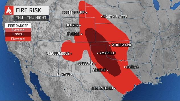 |
| This image depicts several levels of wildfire danger on Thursday forecast by the National Weather Service’s Storm Prediction Center. |
“Regions surrounding far northern Texas and the Oklahoma Panhandle have received less than 0.50 of an inch of precipitation over the previous month, on average,” said AccuWeather meteorologist Alyssa Smithmyer.
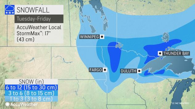
Farther to the northeast, blowing snow will be the primary concern instead of fire danger. Heavy snow will continue to fall from portions of eastern North Dakota and northern Minnesota to northern portions of Wisconsin and Michigan into Thursday.
Even though the snow will be heavy and wet due to temperatures near or just above freezing, forecasters say the wind will be strong enough to cause the snow to be blown sideways at times. The low visibility could cause some motorists to become disorientated in open areas.
 |
As the storm over the Great Lakes finally begins to move away into Canada on Friday, a bit of a breeze will continue, but it will not be nearly as windy as it was earlier this week.
A new storm system may cause winds to increase once again across portions of the Rockies and High Plains by the beginning of the weekend. As this new storm strengthens, surging warmth can again raise the fire danger in central and southern portions of the Plains from this weekend to early next week. Farther to the north, there is the potential for a heavy April snowfall to fall across parts of Wyoming and Colorado to western Nebraska and portions of the Dakotas and Minnesota over the course of Sunday to Wednesday.