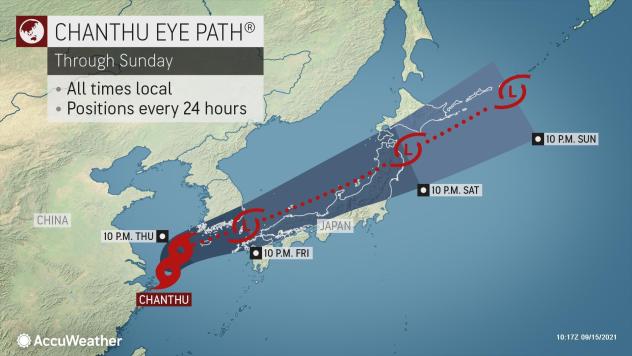
After losing wind intensity and spinning just off the coast of China over the East China Sea for the last few days, AccuWeather forecasters say Chanthu is set to continue its long-lasting journey and impact portions of South Korea and Japan through the end of the week.
Chanthu has amassed quite the track record and has certainly made its mark since first forming in the West Pacific basin last week. Chanthu’s intensity peaked late last week when it became only the second super typhoon of the season after undergoing rapid intensification. The typhoon went on to unleash flooding rain and damaging winds across portions of the Philippines and Taiwan before slowing down and targeting China’s eastern coast this week.
As of Wednesday evening, the eye of Tropical Storm Chanthu was located in the East China Sea. Chanthu was moving slowly to the northwest, according to the Japan Meteorological Agency. Chanthu’s 10-minute average sustained winds were 52 mph, meaning it was the equivalent of a tropical storm in the Atlantic and East Pacific basins.
 |
Forecasters say Chanthu has stalled in this general area since early Tuesday, allowing the storm to bring round after round of heavy rainfall which resulted in flooding for several communities along China’s coast.
At least one location in Zhoushan City’s Dinghai District received 26.1 inches of rain from Chanthu. Elsewhere, more than 300,000 people in Shanghai were evacuated due to Chanthu’s impacts, according to state-affiliated media.
|
While forecasters say Chanthu is expected to pick up forward motion after midweek, impacts for Asia are far from over. “Chanthu will start to push eastward late Wednesday or Thursday and spread heavy rain that could produce flooding in parts of South Korea and Japan from late Thursday into Saturday, local time,” AccuWeather senior meteorologist Jason Nicholls explained. |
 |
As Chanthu tracks eastward through the weekend, widespread wind gusts of 40-60 mph will be common across the southern portion of South Korea, as well as parts of the Japanese islands of Kyushu, Shikoku and Honshu. Higher wind gusts can occur across South Korea’s Jeju Island and Japan’s Kyushu island.
“The wind threat should ease late in the week, but the flooding risk will remain high,” Nicholls said.
Periods of heavy, tropical rainfall are forecast to drop more than half a foot of rain across the southern coast of South Korea and mountainous areas of Japan by the weekend. Days of tropical rainfall can lead to flooding issues across portions of South Korea and Japan.
 |
Low-lying and poor drainage areas will be most susceptible to flooding at the onset of Chanthu’s rainfall, but as more rain continues to fall, area waterways will begin to swell. In addition, any higher-elevation areas in the path of Chanthu’s heaviest rainfall will be at risk for mudslides due to oversaturated soil.
Due to the threat of flooding and mudslides as well as locally damaging wind gusts, Chanthu is a 1 on the AccuWeather RealImpact&trade Scale for Typhoons in both South Korea and Japan. The AccuWeather RealImpact&trade Scale is a 6-point scale with ratings of less than one and 1 to 5.
 |
In contrast to the Saffir-Simpson Hurricane Wind Scale, which classifies storms by wind speed only, the AccuWeather RealImpact&trade Scale is based on a broad range of important factors. In order to better communicate a more comprehensive representation of the potential impact of a storm to lives and livelihoods, the scale covers not only wind speed but also flooding rain, storm surge and economic damage and loss.
After moving across portions of Japan this weekend, AccuWeather forecasters say Chanthu is set to push into the North Pacific Ocean early next week. It is over the open waters of the Pacific that the system will enter more hostile conditions for development and likely dissipate.